EARTHMODEL FT


EarthModel FT is geological modeling software for superior and dynamic reservoir models. It incorporates all field data and connects to flow simulation for improved drilling and production planning. EarthModel FT produces the fastest and most accurate models.
EARTHMODEL FT COMPLETE Create complex structural models with large numbers of faults. Combine well and seismic data. Determine reservoir properties such as lithofacies, porosity and permeability. Use models for low frequency stabilization in inversion projects. Preserve 3D geologic detail during upscale for geostatistical simulation. Build geomodels quickly and update them automatically. Track changes for a complete audit trail.
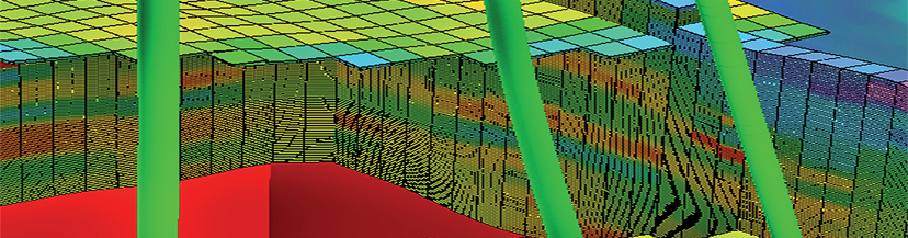
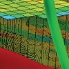
Comprehensive Geological Modeling Cross section through the 3D model. Well with log of facies and zone descriptions. Background of cross section displays facies distribution. EarthModel FT combines surface mapping, integrated structural modeling, reservoir property modeling, upscaling and direct output to most flow simulators all in one package.
EarthModel FT Complete Key Features
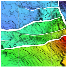
- Powerful mapping and structural modeling with emphasis on complex faulting and volumetric calculations
- Sophisticated stochastic geocellular and object modeling with volumetric analysis within the reservoir model
- Flexible communication with the flow simulator, including fully-featured single-phase upscaling and transmissibility modifiers
- A special technique for upscaling from trace-based seismic grids to corner point grids, for simulators or geological modeling
- UpdateAbility, a breathrough in modeling technology, provides automatic rapid updates when data has changed or been added so you can always keep models current and updated
- Tools to exchange data and models for reservoir characterization and inversion workflow studies within Jason or to external modeling software packages
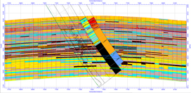
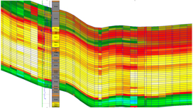
Structural Modeling EarthModel FT Porosity Model Distribution Porosity model distribution with porosity and facies well log curves EarthModel FT handles complex models with large numbers of faults. Assistants in the system guide you through all the steps to make it easy to deal with many faults and horizons. UpdateAbility is fully embedded in this process so that the model can be easily and quickly updated when data inputs change. This includes and is not limited to surface and fault handling and building grid meshes.
Reservoir Property Modeling Reservoir properties, such as lithofacies, porosity and permeability, can be determined by using geostatistical techniques within EarthModel FT, or in combination with Jason’s seismic driven reservoir characterization methods. This empowers EarthModel FT to be fully entrenched in the seismic to simulation workflow, combining the best in reservoir modeling with the best in reservoir characterization. Reservoir Dat
RatingVisits1,626Redirects382Don't Miss Out! Get the Best Deal on this Software - Email Us Now!