GeolMapDataExtractor
- Carry out three point problems to determine the orientation of stratigraphic units, faults, and other types of geologic contacts
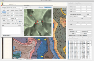
- Use the mouse to drag along a strike line; you type in the dip and the program automatically determines the latitude, longitude, elevation, and strike of the datum. The strikes and dips can be output to your favorite stereonet program or saved as .kml file for visualization in Google Earth using Tom Blenkinsop’s cool 3D symbols.
- Calculate the map thickness of stratigraphic units using any two points, one on the base and one on the top of the bed
- Measure irregular line lengths (both map length and slope length) and areas
- Digitize contacts in latitude, longitude, (and Eastings and Northings) and elevation using as many points as you want. These digitized contacts can be used in digital down plunge projections and can be exported via .kml files to GoogleEarth.
- Construct topographic profiles along a line of section marked with the unit boundaries, just by clicking on the boundaries and entering an annotation. Because topo profiles can have as many bends in them as you want, in addition to making geologic cross sections, this is useful for constructing river profiles, etc. GMDE can project apparent dips onto the line of section. Profiles can be saved as .SVG files for use in your favorite (modern) graphics program
Rating
Visits
1,993
Redirects
630
Don't Miss Out! Get the Best Deal on this Software - Email Us Now!