GeoScene3D-Voxel Builder


Voxel Builder
Voxel Builder is a specialized add-on module tool for building voxel models in GeoScene3D. The module is well suited for geoscientists in public and private organizations working with engineering geology, groundwater, soil contamination, surface near water flow in the field of WSUD and future climatic assessments or other tasks involving compilation and interpretation or visualization of a variety of data types and having a need for a high detail in the geological model. Voxel Builder contains several tools developed to assist the modeller in the modelling process. Layers, regions, shape-files etc. can be imported and used for visualization and/or selection and adding properties to voxels. These tools makes it easy to implement e.g. human structures such as traces at pipelines and road beds, basements etc. into geological models, and make very detailed models in e.g. urban areas in relation to surface near hydrology and climatic changes.
3D Voxel grids and sizes
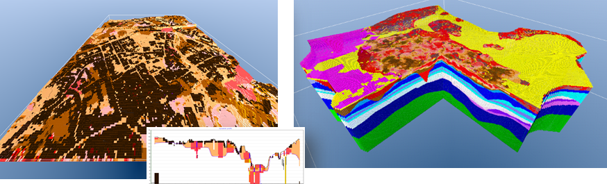
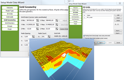
Voxel models in GeoScene3D are based on regular 3D grids, where each grid cell defines a voxel. The sizes of the voxels in the grid are user defined. The voxels can be assigned different parameters, e.g. lithology, age, transmissivity, porosity etc. and can be used for several purposes from large to small scale models. Several voxel grids can be linked in the modelling process.
Modelling Tools and Data
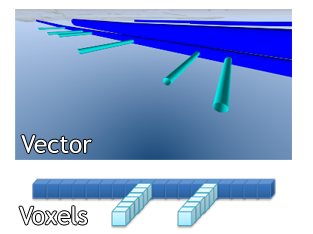
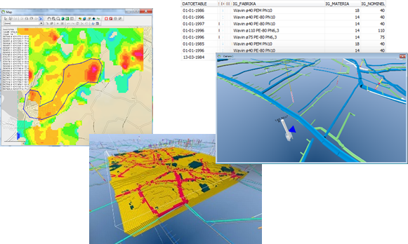
A large number of data types can be visualize and used to select and fill out voxels, e.g. borehole information, geophysical data, layer boundaries, XYZ point information, 3D grids and vector based data (e.g. water pipes, roadbeds, basements etc.).
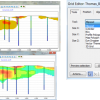
User Interface
Voxel Builder is an add-on module to GeoScene3D. Model setup and data import and -export are assisted by integrated wizards in GeoScene3D, which helps the user during model setup. The Voxel Builder user interface is simple and systematic, restricted to one window containing 5 tabs.
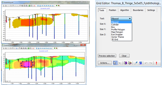
Profile Polygon Tool
Tool used to manually define and draw a polygon on a cross section. The tool is useful when interpreting borehole data, geophysical data etc.
Map Polygon Tool
Tool used to manually define and draw a polygon on a map in the Map Window (example based on geophysical data). Vertical extend of selection is user defined.
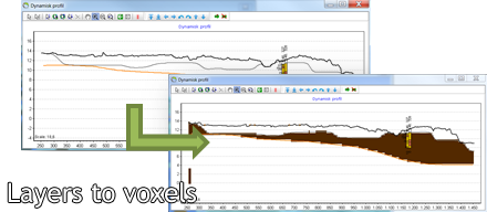
Layer models to voxel models
Layers from e.g. a geological layer model can be converted to voxels. Layers and regions can be used as limits.
Vector Theme Tool
Shape files can be visualized and used as a basis for selection and parameter assignment in a voxel grid. Attributes, like diameter or construction year, can be used in several ways, e.g. dimensioning and coloring a theme.
Rating
Visits
1,158
Redirects
229
Don't Miss Out! Get the Best Deal on this Software - Email Us Now!