RockScale
RockScale® transfers 3D models from orthogonal (seismic) grids to corner point grids. Its unique Zonal Adjustment technique ensures proper mapping of the seismic property samples into the correct stratigraphic layers in the Corner Point Grid. Flow geometry is preserved for NTG, Porosity, and other volumes. Seismic derived property models are rescaled directly into the CPG models. The rescaled CPG models can be used directly or as 3D trend models for co-simulation in EarthModel® FT or other geomodeling programs.
Full Use of 3D Seismic Improves Accuracy
EarthModel RockScaleEngineers and geologic modelers have long realized that incorporation of seismic data can improve the predictive capability of their reservoir models. The limitations have been in using the full 3D seismic or seismic-derived petrophysical properties to build the model, rather than simply reducing the 3D data to 2D maps of the average attribute in the reservoir layer.
RockScale uses the new Stratigraphic Model Grid (SMG) along with Corner Point Grids (CPGs) to manage the transform of the properties (from one grid to the other) and ensure that they are structurally and stratigraphically correct. This includes the management of detailed structural models with many faults and sub para-sequences.
Additionally, Corner Point Grids can be rescaled into orthogonal grids to produce seismic synthetics for model QC purposes. This workflow can be used for evaluating 4D seismic studies and their relationship to fluid movement and detection using seismic data.
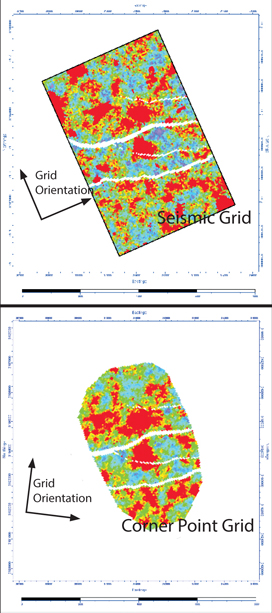
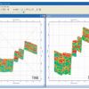
Rescaling Orthogonal to Corner Point Grids
RockScale enables regridding and scaling in three dimensions of seismic derived properties from (orthogonal) gridding systems into mesh (CPG) gridding systems used in geologic modeling. It works in time and in depth and has the ability to regrid properties using its unique Zonal Adjustment algorithms. These properties can then be used in a true 3D sense to assist in building more accurate reservoir models.
Critical Rescaling Issues for Seismic Models
RockScale handles critical issues in preparing multi-million cell models from seismic and properly preserves geometry (including flow geometries) and volumetrics for any volumes prepared in a seismic gridding system, including:
- Net to Gross
- Effective Porosity
- Impedance (Shear and Acoustic)
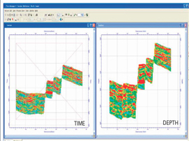
Time Depth Conversion
RockScale has the unique ability to take seismic properties in time and sample them into depth grids prepared in EarthModel FT or other geomodeling packages.
The workflow requires that the depth converted surfaces and faults are the same in both models and that similar methodologies were used in each to describe the stratigraphic layering.
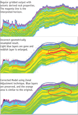
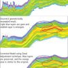
Adjustment
Zonal Adjustment is RockScale’s method for properly incorporating 3D properties derived from the seismic data int
Rating
Visits
1,321
Redirects
331
Don't Miss Out! Get the Best Deal on this Software - Email Us Now!