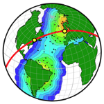
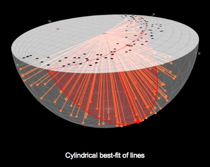
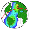
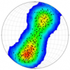
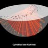
Stereonet3D (previously OSXStereonet) plots lines and planes in spherical, equal angle or equal area, projections. The program can produce various types of plots such as scatter plots, great or small circles, arc segments, contours, rose diagrams, stereonets from any view direction, latitude-longitude data (e.g. coastlines), full screen 3D view of the spherical projection, and Map/Satellite view of data with lat-long information. Stereonet3D can perform various operations, including calculating poles to planes, rotating planes and lines, constraining lines to lie on their planes, angle between lines or planes, cylindrical best fit, conical best fit, and mean vector. Data with lat-long information can be exported to Google Earth. Stereonet3D runs on Mac OSX 10.9 or later. It is available for free on the Mac App Store. To test the program's Map view and export to kml, here is one file with strike/dip data from the Big Elk anticline in SE Idaho (right click to download and open it with the program's File -> Load Dataset from txt menu).
Don't Miss Out! Get the Best Deal on this Software - Email Us Now!