VisLog

VisLog to convert your borehole logs to a 3D, interactive model of subsurface soil layers without the hassle of using expensive and complex computer programs.
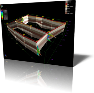
Once all borehole information is entered, drawing the soil profiles is done automatically. A 3D model is prepared which can be easily rotated and zoomed by using mouse. Similar soil layers between adjacent boreholes are automatically recognized by VisLog and connected together to form the profile. A unique shading or color is then assigned to each soil layer and a legend is shown on top-right corner of page.
VisLog allows you to define “soil groups” may consist of several “soil types”. One hatch or color is assigned to each group for visualization purpose.
Soil types can be defined by user, however default soil types include Unified Soil Classification System as well as most of the soil classes used by gINT software. User can add new soil types and soil groups if necessary.
SPT / DCPT / CPT test results can also be plotted beside each borehole. When 3D model is ready, it can be saved as image format or exported to video file.
When the soil profiles are ready you can export it to:
– AutoCAD DXF file
– Image file
– Video file
– Google Earth model
Rating
Visits
926
Redirects
194
Don't Miss Out! Get the Best Deal on this Software - Email Us Now!