EMU
Modeling
Modeling and inversion are the cornerstones of 3D EM data analysis. Inversion is the ultimate depth-conversion tool for turning EM data into resistivity, while modelling allows us to test geo-model hypotheses in the survey planning stage, as well as the interpretation phase.
Sensitivity studies and survey designs
A well-planned survey is a prerequisite for success. At the pre-survey stage, we use 3D model builders to create as accurate and complex geo-models as the existing information allows.
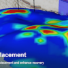
By using our proprietary software EMUTM, we simulate a full EM survey, and rapidly assess our technology's sensitivity to the customer's target of interest in order to gain an understanding of project potential prior to survey commitment.
Moreover, we demonstrate for the customer how information from CSEM can be used to update their assessments of an existing prospect's risk and volume.
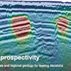
Forward modeling
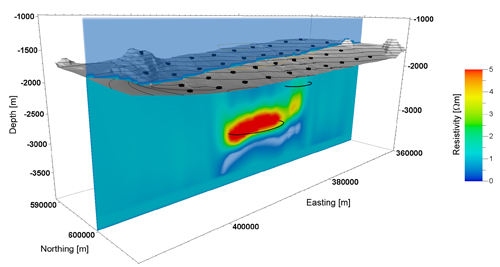
Our inversion schemes can handle any survey layout and anisotropic media, enabling us to depth-convert any EM data set, acquired with any geometry - anywhere in the world. In 3D inversion of 3D EM data, we automatically include the broadside field, which provides valuable extra information compared withtraditional inline field inversions.
An important step in the analysis phase is the inclusion of constraints. We can use structural information from seismic data and resistivity information from well data to guide the inversions. Subsequently, we interpret the inverted model and build a geo-model hypothesis that we test using modeling. This important step ensures that we test the robustness of the inversion results and the subjectivity that lies in any interpretation.
Our 1800 node cluster ensures that we have the capacity to turn projects round quickly and with sufficient iterations to ensure a geologically meaningful result.
Key features
- 1D, 2D and 3D modeling solutions for CSEM and MT
- Bathymetry handling
- Finite-difference modeling code that works in modified time-domain to drastically reduce the velocity dispersion. Our code uses PML, medium upscaling, long differential operators, and interpolation operators and takes into account discontinuities of field derivatives at the seafloor.
Rating
Visits
1,266
Redirects
338
Don't Miss Out! Get the Best Deal on this Software - Email Us Now!