GVERSE Inversion
This plug-in is a colored inversion solution that provides a rapid, yet robust way to derive geological details in the form of a relative impedance (rock hardness). When geosteering through a reservoir, the high resolution impedances calculated by the colored inversion ensure that the well is drilled through ideal reservoir. GVERSE Inversion is completely integrated with the GeoGraphix® suite of products.
GVERSE Inversion is accessed from within the SeisVision application. The plug-in receives seismic and well data from SeisVision, processes it, and returns the inverted volume to SeisVision. To launch the plug-in, open the SeisVision module, and then select Tools >> GVERSE Inversion.
Benefits:
High Resolution Results for Better Well Planning, Geosteering, and Completions
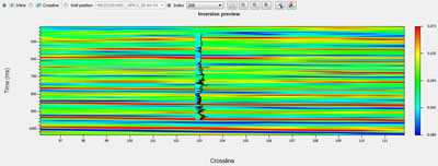
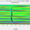
The resulting impedance (rock hardness) data provides a high resolution view of the reservoir and landing zone with the spatial resolution that inherently comes with seismic data. This information can be used to determine the best wells to drill, the optimum landing zones, and provide a better understanding of where and how completions should take place along a well.
Simple, Fast, and Robust Algorithm
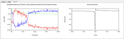
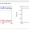
The only inputs for this inversion are the acoustic impedance logs and seismic data to use. With this information, an inversion operator is constructed to quickly transform the seismic amplitude into impedance volume.
Capability of GeoGraphix with FracGeo Technology
Integration of GVERSE Inversion into GeoGraphix allows one to easily create and view the resulting impedance volume and use the derived reservoir information to easily adjust any well locations and geosteering or completion plans.
Rating
Visits
1,015
Redirects
285
Don't Miss Out! Get the Best Deal on this Software - Email Us Now!