Gridding and Mapping Web Start Version
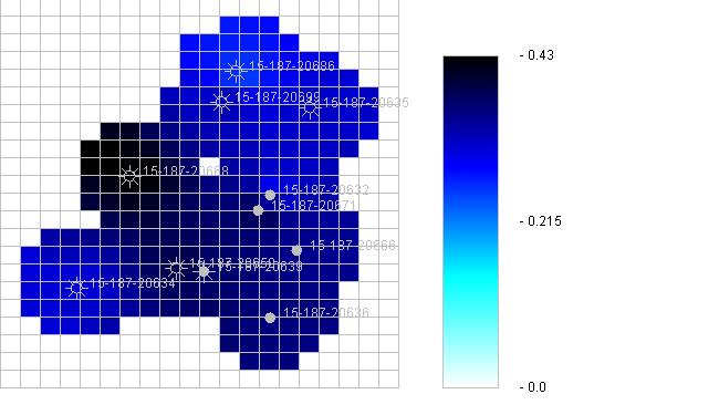


The Gridding and Mapping Web Application is an interactive process that assists the user in building simple color contour maps of Oil & Gas Well data, the user is in control of what data is to be mapped.
The Gridding and Mapping Web Application saves the user's data on the user's PC and not at Kansas Geological Survey's (KGS) Database. This Web Application uses a JAR Signing and Verification Tool to protect the Web Application from being modified by anyone else except the developer of the application. This tool provides the capability to verify the signatures and integrity of the Web Application. The Web Application cannot be forged, the verification process is also a function of the data that was originally created with the original signing process and can not be altered. If the data has been changed the verification signature will no longer verify as being authentic.
This Web Application also saves the user's data as Extensible Markup Language, XML, Files. It provides an ideal solution for handling the rapidly expanding quantity and complexity of information that needs to be delivered on the Web. This Web Application will create a number of XML Files that will be maintained in a KGS Application Data Project Directory Structure on the user's PC. As other Web Applications are developed by KGS the data will use the same directory structure to save and share the user's data. An example is Well Header Information, a XML File has been created with this module that will have the capability of being read by other KGS Web Applications. This will save time for the user and be able to extend their analysis to other modules like GEMINI Project except that the data is on the user's PC.
The Gridding and Mapping Module is a piece of the Volumetric Module that was created for GEMINI Project. While GEMINI was being developed many of the GEMINI partners have voiced concern about having to upload their data to Kansas Geological Survey (KGS) in order to analyze fields within their region of interest. The design of the Web Application will allow the user to save their data on their PC.
The Web Application may be run as an Applet or as a Web Start Application. The Applet version of this Web Application runs on the web, but saves the data to the user's PC. This is allowed because this Applet was created as a trusted applet in which the user gives permission for the Applet to save data on the user's PC.
This module does provide the capability to access Kansas Geological Survey's Database to retrieve Well Header Information for each Kansas oil & gas well that is being added to your project. It also sets up the future capability of accessing other Servers for oil & gas data. A Server List XML is included with the Gridding and Mapping Module and is read each time the program is executed. The Gridding and Mapping Module reads this file to determine the public Servers the Module can use to retrieve oil & gas data.
Rating
Visits
1,020
Redirects
257
Don't Miss Out! Get the Best Deal on this Software - Email Us Now!