GWN-COGO
Surveying, Mapping and Subdivision Design
GWN-COGO is a comprehensive tool for surveying, mapping and subdivision design. GWN-COGO is available as an AutoDesk or MicroStation add-on providing a low-cost surveying application alternative which runs inside AutoCAD or MicroStation. GWN-COGO provides surveyors and civil engineers with comprehensive Coordinate Geometry Software that offers a true database linkage. GWN-COGO can also be linked directly to commercial databases enabling easy transition into GIS.
GWN-COGO provides advanced commands for transformations, which enable users to reference data from different sources. The ability to reference data will increase the accuracy of the resulting map or design. With GWN-COGO users can do Affine transformation, Helmut transformation, three axis, scale and offset transformations. Other adjustment commands include compass closure with angular misclosure.
GWN-COGO includes a multitude of subdivision design related options, including a number of commands to create cul-de-sacs, intersections and right-of-ways. These automated commands greatly simplify the design process enabling civil engineers to complete projects in shorter time. GWN-COGO also allows users to copy parallel lines, reducing the number of commands required by users.
- Location related to distance, direction, angle, bearing, deflection
- Duplication of an existing point
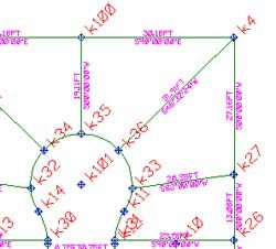
- Intersections of combinations of figures, distances, direction, lines, arcs, offsets, points
- Division and proportion of lines, arcs, area and direction adjustments
- Curve, Spiral, Arc calculation and generation commands
- Set points using a boundary traverse or sideshot with turned angle, North or South azimuth
- Select the points you need for a radial stakeout using Turned Angle or North or South Azimuth
Rating
Visits
1,057
Redirects
256
Don't Miss Out! Get the Best Deal on this Software - Email Us Now!