GWN-DTM
Digital Terrain Modeling and Contour Mapping
GWN-DTM is a powerful digital terrain modeling package ideal for even the biggest civil engineering projects. GWN-COGO is available as an AutoDesk or MicroStation add-on providing a low-cost surface contouring application alternative which runs inside AutoCAD or MicroStation. With GWN-DTM users can easily create contours, overlay grids, calculate volumes between surfaces, and substitute elevations with other data sets for contouring. for the design of dams, lagoons, settling ponds, landfills, roads or other surface features.
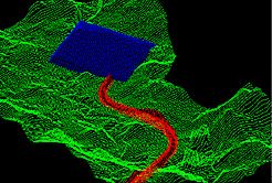
GWN-DTM is an ideal application for large scale earthwork projects, such as design of dams, lagoons, settling ponds, land fills or roads.GWN-DTM’s unique GIS Quadcell approach allows for use and manipulation of unlimited number of points – current projects include over 4,000,000 points– in a single file effortlessly and expediently. The first class visualization tools of GWN-DTM allow users to quickly analyze surfaces and evaluate cut and fill requirements. GWN-DTM also accepts feature codes from survey reports, which can be used to quickly identify and analyze elements.
Rating
Visits
1,086
Redirects
278
Don't Miss Out! Get the Best Deal on this Software - Email Us Now!