Rick
Stereonet 9 Popular
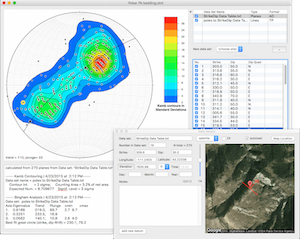
Stereonet 9 brings location and date tagging of individual measurements as well as a free form notes field. Points with location data can be plotted on a Google satellite (or terrain or roadmap) image right in the program. This version of Stereonet is compatible with all modern operating systems and ...
Read More ...
FaultKin 7 Popular
FaultKin 7 is a complete rewrite of my venerable fault slip analysis programs for Mac and Windows. The program has a revamped, and vastly improved, user interface, includes most of the scientific functionality of the older versions, and will work just fine on modern operating systems such as Mac OS ...
Read More ...
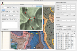
GeolMapDataExtractor is a program to extract information from a scan (raster image) of a geologic map or image of known scale. A huge assortment of maps are available for free online from the USGS and the GSC, or you can scan your own maps. StrikeDipThickness can read .jpg, .jp2, .png, .tif, and .pd ...
Read More ...
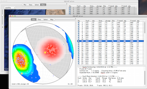
MohrPlotter Popular
MohrPlotter is a simple program to plot Mohr Circles for stress and do simple calculations related to them. It was written to help structural geology professors and students quickly and accurately construct Mohr diagrams so that will have to spend less time plotting and more time exploring the resul ...
Read More ...
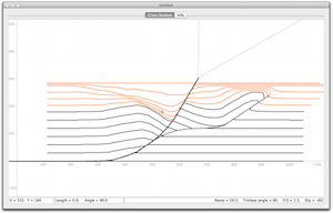
FaultFoldForward is an update of the forward modeling part of my program FaultFold. It has an updated interface and the forward modeling part has added functionality over the original program. Eventually, the inverse modeling part of the original program will be added but I wanted to get this into t ...
Read More ...
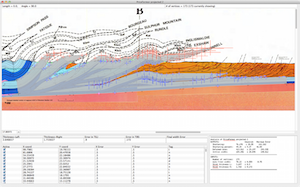
AreaErrorProp is a complete program with modern graphical user interface (GUI) to carry out the analysis of uncertainties in area balancing on both Mac OS X and Windows operating systems. Its primary purpose is to estimate the error on shortening magnitude and percent based on the uncertainties assi ...
Read More ...
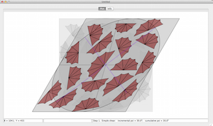
StrainSim 3 is an update of my simple forward modeling program to simulate simple shear, pure shear, and progressive deformation. This version is compatible with the latest Mac and Windows operating systems. The program is designed as a teaching and visualization device. As such it can animate progr ...
Read More ...
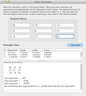
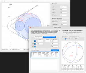
One of the primary uses of eigenvalues and eigenvectors in structural geology is to calculate the principal axes of tensor quantities like stress, strain, or the orientation tensor. The actual numerical methods for calculating eigenvalues are beyond the background of most introductory structural geo ...
Read More ...
This program will read and parse a KML file, allowing one to save the data as a table of tab-delimited text. The name of the placemark, latitude, longitude, altitude, and any contents of the description field are saved to separate fields of the text file. Additionally, multiple vertices of any polyg ...
Read More ...
This is a small utility program to translate Longitude and Latitude coordinates into UTM coordinates and vice versa. You can choose from several different map datums, edit data and have it converted instantaneously to the other format, etc. Additionally, it can calculate all of the coordinates in a ...
Read More ...
Page 1 of 2
- 1
- 2