scientificsoftwaregroup
Create Informative and Impressive 3D Images for your Groundwater Flow and Transport Models!
Introduction
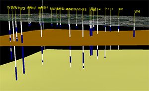
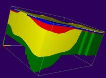
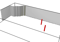
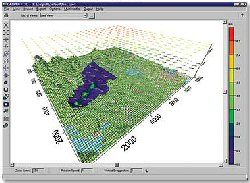
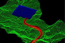
The software package 3D Master (GE) provides for three-dimensional visualization and animation of data from groundwater flow and transport models. The current version of GE uses any native MODF ...
Read More ...
ArcGIS is a family of software products that form a complete GIS built on industry standards that provide exceptional, yet easy to use, capabilities right out of the box. ArcGIS is a complete, single, integrated system for geographic data creation, management, integration, and analysis.
Much more t ...
Read More ...
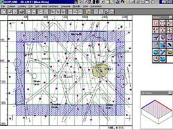
Bioplume III is a two-dimensional, finite difference model for simulating the biodegradation of hydrocarbons in groundwater. The Bioplume III model simulates both aerobic and anaerobic biodegradation processes in addition to advection, dispersion, sorption and ion exchange. Bioplume III simulates th ...
Read More ...
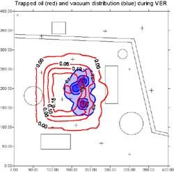
Multiphase Hydrocarbon Vacuum Enhanced Recovery (Bioslurping) and Transport
BIOSLURP is an areal finite-element model to simulate three-phase (water, oil and gas) flow and multicomponent transport in ground water in the unsaturated zone gas phase. BIOSLURP can be used to optimize the recovery of LN ...
Read More ...
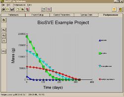
Soil Vapor Extraction (SVE) and Vacuum Enhanced Recovery with Bioventing
BioSVE incorporates soil vapor extraction (SVE), vacuum enhanced recovery (bioventing) and biodegradation into one easy-to-use screening model. BioSVE is a user-friendly screeing tool which allows site evaluation with limited ...
Read More ...
Complete Interface for Puff Dispersion Modeling with CALPUFF/CALMET and CALPOST
CALPUFF View supports the EPA approved version 5.8 and the advanced version 6.0 of the CALPUFF system and includes powerful and independent QA tools, stunning report ready results and a wide range of visualization optio ...
Read More ...
Enter a New Era in Digitizing Technology
Didger 4 is a highly accurate digitizing software program that will be an invaluable addition to your software library. In seconds, Didger precisely transforms points, lines, or areas from your paper maps, graphs, aerial photos, scanned raster images, import ...
Read More ...
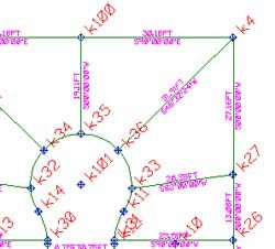
Surveying, Mapping and Subdivision Design
GWN-COGO is a comprehensive tool for surveying, mapping and subdivision design. GWN-COGO is available as an AutoDesk or MicroStation add-on providing a low-cost surveying application alternative which runs inside AutoCAD or MicroStation. GWN-COGO provides s ...
Read More ...
Digital Terrain Modeling and Contour Mapping
GWN-DTM is a powerful digital terrain modeling package ideal for even the biggest civil engineering projects. GWN-COGO is available as an AutoDesk or MicroStation add-on providing a low-cost surface contouring application alternative which runs inside Au ...
Read More ...
Surface Modeling, Mapping & Design
GWN-SURF is an ideal application for surface modeling and mapping projects. GWN-SURF is a world class surface modeling package, with advanced contouring, profiling and slope analysis capabilities. GWN-SURF is available as an AutoDesk or MicroStation add-on pro ...
Read More ...