QPS (IVS 3D) Fledermaus
Fledermaus is a powerful system of interactive visualization of 3D data used for various applications, including environmental impact assessment, mining, geology and scientific research.
Innovative data mining functions, including ShiftScape TM rendering engine and the Bat (3D input device), allow for intuitive viewing spatial data.
It supports a wide range of standard formats, allowing direct import of data into 3D scenes. Types of objects such as digital terrain maps, clouds of points, lines, polygons, satellite, etc. Can be simultaneously loaded and analyzed in one scene. Due to the flexibility of object-oriented software architecture, Fledermaus can be easily adapted to work with many additional visualization modules.
If you want more information on Fledermaus software, full documentation is available on the Internet. Also available is a free program for viewing files called iView3D.
Functions
- Automatically scale display system from high-end to low-ends using the rendering engine ShiftScape TM .
- Many spatial data with different resolutions can be viewed interactively visualized and at the same time.
- Integrated support for very large data sets.
- All data sets in a 3D scene can be geo-referenced.
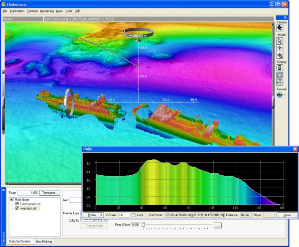
- Users can interactively interrogate data sets to select coordinates profiles and measurements.
- Advanced object-oriented architecture allows easy integration of new data types in the system.
- The search can be recorded and used to create movies of data mining session.
- With the right equipment you can display graphical visualization in 3D stereo.
- Software and data files can be used in a wide variety of computing platforms from laptops to powerful visualization systems.
data types
- Numerical mode area.
- Seismic data subsurface.
- Images, such as maps, plans, aerial photographs and satellite images.
- Pictures such as flat geo-reference plane 2D substrate or applied to images vertical.
- Measurement of planes and networks.
- CAD DXF format.
- Models 3DS or OBJ files.
- Animated surfaces.
- ArcView data (shape files, grids, and imagery).
- Data from a variety of formats and multi-beam sonar procesingu - GSF, CARIS HDCS, SHOALS, HTF, and ASCII.
The amount of data
- Integrated support for very large data sets.
- The size of the data set is not limited by the software.
data processing
- The software allows you to import survey data from multiple formats including ASCII xyz and GMT GRD / NetCDF, Etopo2 and 5, USGS DEM database NOAA Gravity, Grass, binary raster data, DTED, ArcView, ERMapper, and many others.
- You can easily add new data formats.
- The surfaces are color
RatingVisits1,768Redirects276Don't Miss Out! Get the Best Deal on this Software - Email Us Now!