Petrel Well Trajectory Planning
The well path design and positioning capabilities in the Petrel* E&P software platform are now fully coupled to perform wellbore stability evaluation, offset well analysis, and relief well planning.
The Petrel Trajectory Planning module enables collaboration between geologists and drilling engineers to efficiently deliver a drillable trajectory with constraints and sensitivity analysis. This provides a unified visualization, interpretation, and modeling workspace in which teams can collaborate more effectively to plan wells and evaluate and develop assets.
Reduce trajectory planning cycle time
Enhanced collaboration enables multidisciplinary experts to work more effectively to design the optimal trajectory, run anticollision analysis, and leverage 3D visualization tools. Extending well path design to geomechanics workflows substantially changes the way well paths are built, allowing geologists and drilling engineers to select the right trajectory and mud weight.
Trajectory planning cycle time is reduced by using a shared workspace to design well paths and run both anticollision and driller target analysis in the context of the earth model. The multiuser environment in the Petrel platform enables this integration across multiple domain workflows and data types.
Integrated trajectory workflow in 3D earth model
The well path design and well positioning workflows use industry-standard engines to enable you to quickly design and validate all well trajectories, drillable wells, sidetracks, and multilaterals, as well as perform drilling target and anticollision analysis—all in the context of your 3D earth model.
Once the wells are planned, attributes can be adjusted for cost, directional complexity, and platform locations, while ensuring maximum reservoir contact. All changes are viewable in geological context within a 3D window.
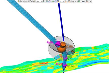
The well positioning workflow increases confidence in anticollision analysis by visualizing critical results within a 2D or 3D space: this is especially useful in congested offshore or land development environments. Calculating the no-go zone for each offset well steps down each ellipsoid of uncertainty of the offset well trajectory and computes the perpendicular cross section as well as the minimum allowable separation distance for each direction. The 3D no-go space is constructed by connecting all of the no-go cross sections on each offset well, from wellhead to TD.
Project or window anticollision scans can be run interactively while planning or drilling. Collision risk levels are highlighted in a window—high-risk level displayed in red, low-risk level in green—providing a quick indication of the success of the anticollision scenario.
Integrated geomechanics
The Mud Weight Predictor (MWP) plug-in for the Petrel platform provides advanced wellbore stability postprocessing for your geomechanical models. The purpos


