CSEM Forward Modelling
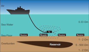
The marine controlled source electromagnetic (CSEM) method is a low-frequency electromagnetic imaging technique aimed at generating the electric resistivity map of seafloors. In a CSEM survey, an electromagnetic transmitter and arrays of electromagnetic (EM) receivers are used to probe the subsurface. Once an area of interest is electromagnetically surveyed, the recorded data is used in an EM inversion process to obtain the required resistivity map. Currently, the method is mostly used as a complementary tool to seismic surveys and well data analysis. Therefore, the stratification of the subsurface is already largely known, but the EM characteristics of each layer still need to be determined. The knowledge of EM properties allows differentiating between reservoirs that contain hydrocarbons and those of no commercial interest. Traditionally this method was relatively expensive to implement due to high computational costs. However with the improvement in speed of the computational devices and effectiveness of the algorithm, the CSEM method has only recently been employed on a commercial scale as a tool for hydrocarbon exploration.
Listing Details
Visits
1,225
Redirects
301
Don't Miss Out! Get the Best Deal on this Software - Email Us Now!
Map
© OpenStreetMap contributors
more information about CSEM
Hi there, how can I get more information about this software? please advice. 


