DV-SeisGeo
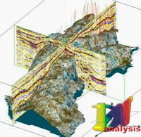
DV-SeisGeo is designed to create and maintain 3D digital structural-parametric models of oil and gas reservoirs from integrated dynamic interpretations of 2D/3D seismic, well logging, geological, petrophysical and oilfield data, and to study such reservoirs on the basis of paleo-tectonics and paleo-sedimentation analysis data.
DV-SeisGeo system is a universal tool for dynamic visual analysis of large sets of geoscience and oilfield data in multi-dimensional and multi-parameter spaces.
This system allows estimation of hydrocarbon reserves, using 2D/3D models, in compliance with regulatory documents. DV-SeisGeo facilities enable auto correlation of seismic and well logging data and the tracing of faults. General aims of DV-SeisGeo application for oil and gas reservoir modeling:
- optimal structural-parametric reservoir modeling on basis of agreed sedimentation analysis of multi-parameter geological cubes and seismic attributes;
- detailed study of sedimentation, structure formation, drift directions and so on on basis of paleotectonic analysis;
- allocation of volume regions with specified parameters;
- reservoir characteristic map construction taking into account its structural and lithologic details;
- construction and monitoring of a grid geological model to solve hydrodynamic problem lossless important geological details.
Solved problems:
- import of any geologic-geophysical data in a project database that allows you to select data by a set of filters, to preview and analyze the initial data;
- efficient access and use of the initial data, intermediate and final interpretation results of different methods that rest upon the integrated project database that includes all information concerning the pool exploring and development;
- traveltime and amplitude 2D and 3D seismic interpretation;
- seismic modeling (including inversion) and stratigraphic tie of reflections;
- 3D modeling of reservoir petrophysical properties, lithofacies and field characteristics on basis of well data interpretation results;
- prediction of reservoir filtration characteristics;
- determination of local anomalies;
- reservoir volume calculation and estimation of reserves;
- data preparation for hydrodynamic simulation that guarantee 3D model structure and homogeneity of reservoir properties preservation when performing the upscaling of a 3D geological model;
- data preparation and calculation for multi-dimensional data analysis;
- creating hardcopies
The system main features:
- multiple volumes of 2D and 3D seismic data can be loaded into a single project and viewed simultaneously;
- All associated data volumes and base maps are linked with active cursors, scrolls and zooms;
- Split screen viewing permits multiple data sets(geological an

