PALEOSPARK
PaleoSpark delivers the most coveted outcome in stratigraphic interpretation – a fast and accurate depiction of the true paleo-depositional environment. This revolutionary solution removes the structure that’s standing in the way of successful characterization. Complexly faulted areas now reveal channels and other stratigraphic features as they were originally deposited.
Remove the structure and see the geological truth
With PaleoSpark, hydrocarbon deposits have nowhere to hide. See the depositional environment throughout the stratal volume and confidently recommend the best path for extraction in the structure volume.
Industry Challenge
Defining the paleo-depositional environment is a guessing game. The best that traditional interpretation systems can do is to image the environment in single stratal slices that can be created near interpreted horizons by flattening on a horizon. Anything ventured beyond this known horizon, accuracy vanishes.
PaleoSpark Solution
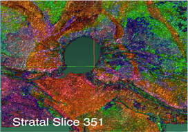
PaleoSpark reveals the true paleo-depositional environment in all of its glory. It removes all 3D structural effects from a volume, so that every horizontal slice output is an actual paleo-depositional surface. This workflow provides a clean stratal volume that allows accurate imaging of all depositional systems within it, making exact drilling plans a snap.
- Domain Transformation handles differential sedimentation, differential compaction, unconformities, salt bodies, canyons, carbonate platforms, and can remove most 3D fault displacements
- Surface Wrapping identifies depositional system boundaries, which are then inverse-transformed and merged with the structural interpretation
- Highly accurate mapping of the sweet spot in shale formations helps to guide efficient drilling in unconventional plays
PaleoSpark in Action
The pace of production brings enormous pressure to secure the best leases and quickly find the best locations for drilling. PaleoSpark clears obstructing structural problems and provides an accurate picture of the exploitable volume to facilitate the successful execution of ambitious development plans.
PaleoSpark produces in days what usually takes months with traditional interpretation approaches, and with significantly more accuracy in the results. Now, know the volume as never before, set development priorities, place the planned wells – and produce.
Surface Wrapping and Surface Draping
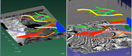
PaleoSpark comes with two powerful tools that add speed and accuracy to interpretation workflows. Surface Wrapping rapidly captures the geobodies contained in the entire volume within precise closed surfaces. Surface Draping quickly defines the surface of a laterally-extensive object with great accuracy. The combination of these two tools significantly reduce interpretation and model building time.


