Geoscience Software
Geoscience is the branch of science dealing with planet earth, including features on the earth’s surface, and below it. In petroleum industry, geoscientists play an important role in finding underground oil and gas reservoirs. They are also involved in mapping and interpreting underground surface interpretation. Today there are a number of advance geophysical software packages available for processing, interpreting and running inversion on reservoir seismic data.
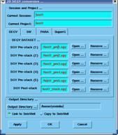
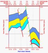
Seismic post-stack (SEGY) data are uploaded into GeoInversion
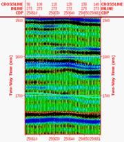
Seismic pre-stack (SEGY) data are uploaded into GeoInversion
External attributes and inversion results loaded into GeoInversion
Seismic HYBRIC attributes, which are a combination of the optimum set of attributes from post and/or pre- ...
Read More ...
Session management including build/delete a session
Project management including build/delete a project
Pseudo-3D seismic management, which composed of seismic 2D Lines (Projects)
Well logs dataset and well position, well marker and trajectory;Seismic 2D/3D geometry (cdpx, cdpy) management
Wel ...
Read More ...
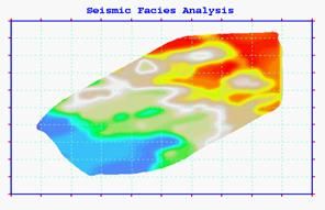
seisFacies When there are few wells available for reservoir description, the seismic attributes can be used to study stratigraphic facies. The sliced attribute/property, which can be generated from our GeoInversion system, is new geologic time surface by proportionally slicing between reference seis ...
Read More ...
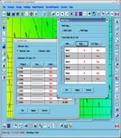
Vp/Vs/Den Inversion (seisInversion): There are two methods for seismic inversion. The first method is (non-)Linear Conjugate Gradient method to estimate the Vp, Vs and density. Another method is Bayesian-based Support Vector Machine method to incorporate the petrophysical property and seismic attrib ...
Read More ...
Seismic Geological Modeling (seisSuperMan) An advanced horizon and fault manipulation tools, including interactive picking of target horizons and faults. The tool also supports to load seismic horizons from other system. The target layers, which build the geological models, compose of top/bottom hor ...
Read More ...
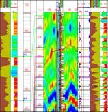
AVO/AVA Attribute Designed to extract gradient, intercept and curvature from pre-stack seismic gathers. Also when there are noise gathers, the curved-surface function can be applied to extract the attributes to consider both the seismic amplitude-vs.-offset and amplitude-vs.-time. These AVO attribut ...
Read More ...
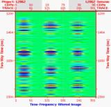
Seismic Time-Frequency Attribute Designed to decompose post-stack seismic dataset into time-frequency panel through an implementation of Match-Pursuit Wigner-Ville Distribution (WVD). The time-frequency panel will be used to propagate logs.
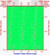
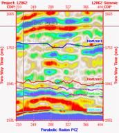
Seismic Time-Radon Attribute Designed to transform pre-stack seismic gathers into time-radon panel through an implementation of Parabolic Radon Transform, which also has been used to de-multiple in seismic processing. The time-radon panel will keep most of seismic gather information including amplit ...
Read More ...
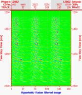
Seismic Time-Velocity Attribute Designed to transform pre-stack seismic gathers into time-velocity panel through an implementation of Fast Hyperbolic Radon Transform, which has been used to de-multiple in seismic processing. The time-velocity panel will keep most of seismic gather information includ ...
Read More ...
Seismic Attribute Analysis The Factor Analysis will be used to classify or reduce the attributes from post and/or pre-stack seismic dataset. Usually Factor Analysis can be applied in order to explore a content area, structure a domain, map unknown concepts, classify or reduce data, transform data, d ...
Read More ...