MapMaker™
MapMaker™ package is mapping module allowing to create and edit maps of various parameters honoring faults. MapMaker MapMaker The functionality of MapMaker™ includes:
- Mapping of various parameters honoring faults ;
- Import/export of cartographic data; Interactive editing of maps;
- Arithmetic and logical operations with maps;
- Export and printing pictures.
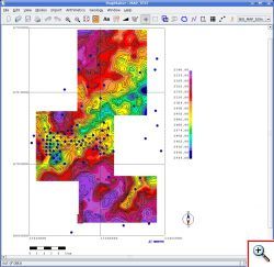
MapMaker™ works with data retrieved from PANGEA data base. MapMaker™ can import scattered data as point sets, line sets, and grids. It is possible to import maps and isolines from external files. Maps, maps geometries, areas, point sets, line sets and fault lines can be edited. Horizons, attributes and point sets can be used as data source for map building. Maps and parameters at the particular points can be modified with user defined formulae. User can also edit maps interactively by selecting an area and smoothing the map out or by fixing the specific value of the parameter in the selected area. In addition, user can edit maps introducing vectors for which values corresponding to the beginning of the vector will affect values at the end of vector. MapMaker™ can be used for solving various geological tasks. THus, structural maps can be constructed using TWT map and value of true vertical depth in wells. True vertical depth can be obtained from log data by calculating the coordinates of intersections with specified horizon. Image of MapMaker™ workspace can be exported as vector or raster picture for printing and editing in graphics editors.
Rating
Visits
2,218
Redirects
393
Don't Miss Out! Get the Best Deal on this Software - Email Us Now!