QuickLog, QuickCross/Fence, QuickGIS, QuickSoil
QuickLog
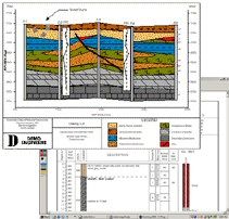
QuickLog greatly speeds and simplifies the process of creating boring logs (borehole logs)/well lithology. Completely menu driven, QuickLog is intended to be used by geologists or data entry staff members to create boring logs diagrams without the need for a CAD system.
New TABLET PC Version of QUICKLOG - Add-on to QuickLog
- Maximize your efficiency by using free time to get boring logs done while in the field - no need to spend days working on logs when you get back to the office.
- Setup PICK LISTS of soil descriptions - choose them with a pen stylus. Makes data entry fast and STANDARDIZED.
- View boring log diagrams, TO SCALE, in the field - helps you make better decisions on where to pull samples and set screens.
- If you have used QuickLog, there is no learning curve - field and desktop versions are virtually identical.
QuickCross/Fence
The QuickCross and QuickFence modules use data already entered in QuickLog to create 2-D cross sections and 3-D fence diagrams. Using the new drawing tools, you can now edit the drawings right on the preview screen.
QuickGIS
QuickGIS enables you to organize the lithology data for a set of borings into a table of X, Y, Z coordinates and geological layers. You can then export this data to ArcView and other GIS systems or use it to enhance the abilities of QuickCross/Fence.
QuickSoil
The QuickSoil module produces a soil analysis table that shows soil sample test results for a set of parameters. Each sample is placed at its correct depth and shaded according to the value of each parameter tested. QuickLog also displays soil sample data -- QuickSoil expands these capabilities by showing more parameters on a page and in different graphical format.


