PLATFORM & ENVIRONMENT
Streamline your workflows. Complete projects faster. Have confidence in your data and in your interpretations. Collaborate across disciplines for the most accurate answers and reservoir interpretations. Connect to 3rd party tools and workflows as needed to characterize prospects. Understand reservoir properties and how they evolve over the life of the field. Our integration platform enables teams to interpret and understand reservoir properties from a combination of approaches, including petrophysics and rock physics, advanced seismic interpretation, seismic reservoir characterization and geological modeling.
Expertise and Workflows for Optimizing Decision-Making
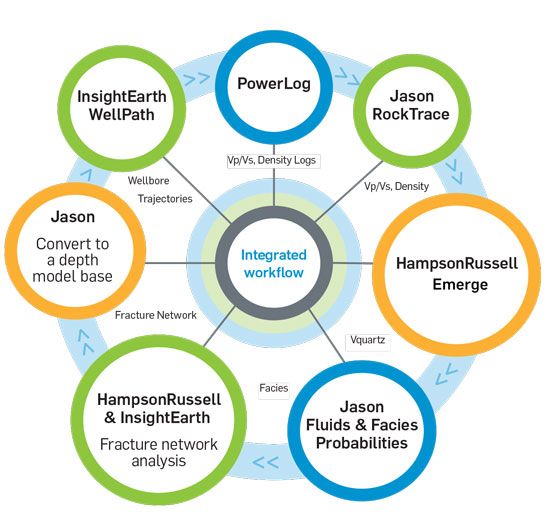
Integration across high-end GeoSoftware workflows and 3rd party industry software platforms enables users to better characterize prospects and understand reservoir properties and how they evolve over the life of the field. A shale gas workflow illustrated below is an example of the many workflows available from GeoSoftware.
Integrated Project and Data Management
CGG’s GeoSoftware platform delivers an integrated project and data management environment dedicated to multi-disciplinary collaboration and seamless cross product workflows. Centralized management of projects, project security, data, and sessions reduces project cycle time and ensures the most current, highest quality data is available.
Our database environment enables direct multi-user access and sharing of all well, lithology, and interpretive information. Easy to use, industry-leading well-data loading tools minimize time spent on data management. Quality control and accuracy of well information is managed with tools designed to help you identify and correct errors or inconsistencies quickly and easily. This is especially critical to quantitative interpretation workflows.
Common access to shared well-data enhances team collaboration. Time spent managing duplicate sets of data in multiple application environments is reduced or removed. Asset teams can leverage business and cross-discipline expertise to assess a reservoir’s geology and make full use of its resources.
The GeoSoftware Gold Standard for Asset Teams
Gain operational value with the ability to escalate key well-data to a “gold” team standard. Eliminate overlapping, alternative and conflicting subsurface interpretations. The GeoSoftware Gold Standard provides a mechanism for asset teams to choose which well and interpretative information becomes the trusted standard for all to use. Divisional boundaries are a thing of the past.
The easy to install technology delivers easy to use data loading and management tools, advanced well journaling, and a unified approach to coordinate reference system management. The platform currently supports the Jason Workbench, PowerLog, VelPro and EarthModel FT applications.

