Pangeos

Geostatistical Simulation and Optimization for the Mining Industry
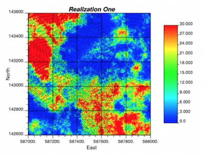
Geostatistical Simulation
- All required preprocessing (declustering, debiasing, and trend modeling)
- Multiple rock types with hard and soft boundaries
- Multivariate simulation of any number of variables
Postprocessing and Optimization
- Recoverable reserves calculation
- Resource/reserve classification
- Dig limit optimization
The Place for Pangeos
There is a number of general mine planning (GMP) software packages on the market. GMP software is well-suited to data management, conventional geologic modeling, visualization, and mine planning tasks. There is a number of specialized geostatistics software packages on the market; however, there are no geostatistical software packages that provide a satisfactory solution to the problems of (1) reliably generating geostatistical realizations of multiple variables within multiple rock types, and (2) providing optimized solutions to reserve estimation and grade control in presence of uncertainty quantified by multiple geostatistical realizations. Pangeos meets the need for focused mining geosta- tistics simulation and optimization software.
Data Analysis
The necessary plots and graphics for understanding your data and validating your model including:
- Histograms and probability plots
- Q-Q plots and scatterplots
- 2-D slice maps and interactive 2-D visualization
Variogram Calculation and Fitting
The required tools to calculate and fit variograms:
- Variogram volumes
- Directional variogram calculation
- Semi-automatic variogram fitting
- Histogram and variogram scaling (affine, ILC, DGM)
Postprocessing
Model postprocessing and checking:
- Validation and distribution transformation
- Recoverable reserves calculation
- Classification
- Reporting within arbitrary volumes and time periods
Preprocessing Tools
The required tools to prepare data for simulation:
- Declustering (cell, nearest neighbor, kriging,...)
- Debiasing with secondary data
- Despiking and transformation (normal/stepwise)
- Trend modeling
Geostatistical modeling
Essential 3D model building tools including cross vali- dation:
- Kriging and simulation
- Hard and soft geological boundaries
- Simultaneous handling of multiple variables
Grade Control
The tools for optimizing dig limits including:
- Expected profit calculation
- Interactive polygon digitizing
- Simulated annealing-based dig limit optimization
- Reporting of ore/waste within arbitrary polygons &